KINGSTON, R.I. – March 13, 2023 – With the recent floods on the West Coast and the approach of the anniversary of the record-breaking March 2010 floods in Rhode Island, University of Rhode Island professor Soni Pradhanang shared insights into the challenges of managing water, demonstrating a URI resource that helps others better analyze and predict water patterns and impact.
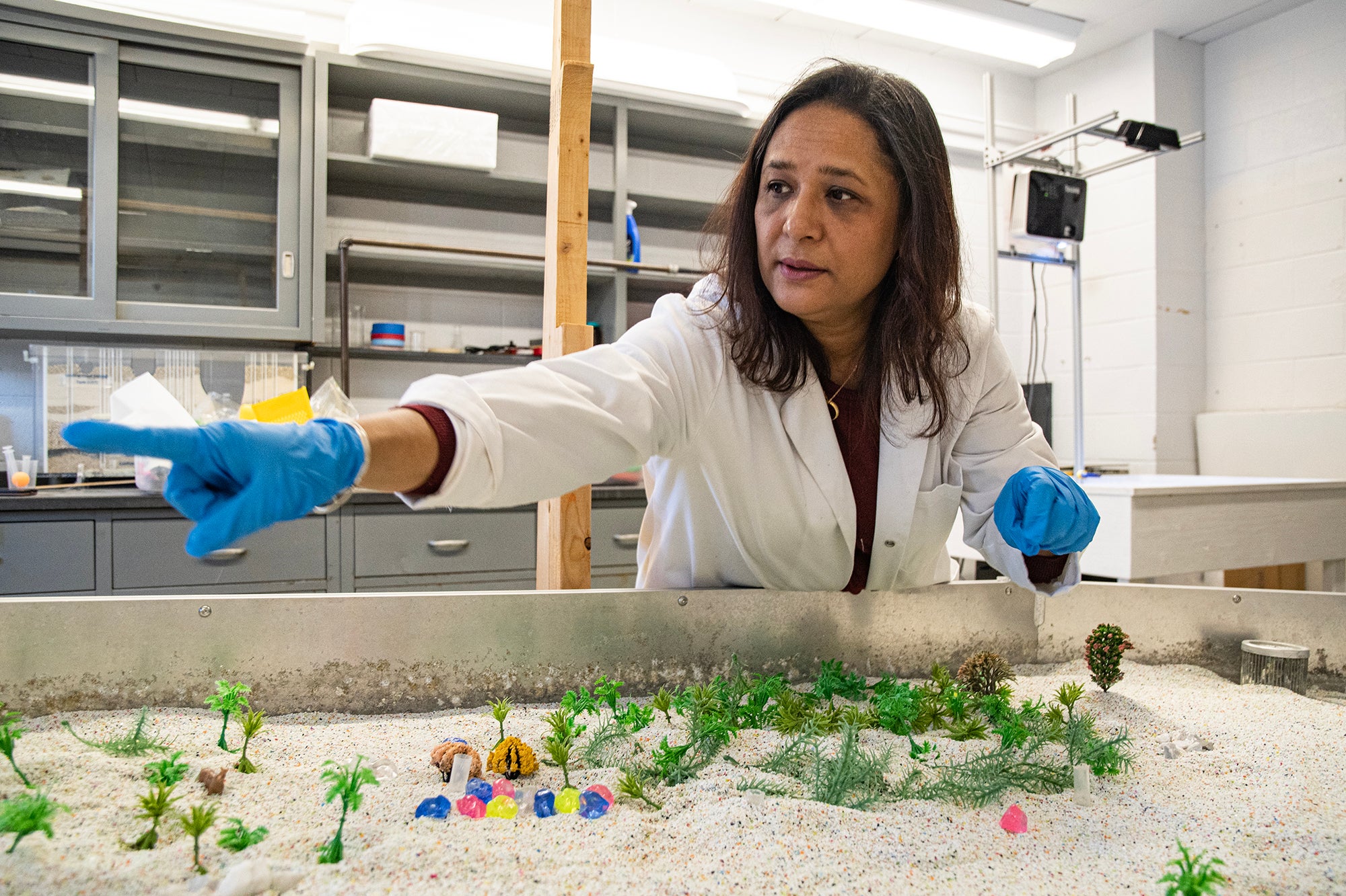
From her home base at URI’s Kingston Campus, Pradhanang keeps an eye on all 20 rivers in Rhode Island, as well as water systems across the country. Her ‘emulated river system,’ located inside Woodward Hall, is a large structure about the size of a ping-pong table. Although using it is certainly fun, the table offers students and planners the chance to float ideas on water use back and forth.
An associate professor of water resources and quality at URI, Pradhanang is part of the University’s “water cluster” on the school’s Geosciences faculty and directs the University’s minor in Global Water Resources. She is also a track chair for the Wetlands and Watershed Ecosystem Sciences, MESM Program. She always has several water projects in the works on campus, working with students or planting floating displays in a nearby creekbed to get passersby thinking about the water flowing beneath their feet. Pradhanang’s work also crisscrosses the state like the rivers she studies, as she consults on water management with a number of agencies, from Rhode Island’s Department of Environmental Management and Department of Transportation to Providence Water and its Scituate Reservoir. She’s a past recipient of the Outstanding Research of the Year Award in the College of the Environment and Life Sciences (2021) and has welcomed international journalists to URI through its Metcalf Institute. She also served on the Committee Report led by the National Academies of Science, Engineering, and Medicine.
Now Pradhanang hopes to collaborate with local K-12 schools and city planners, hoping to invite more visitors to her river demonstration table at work. This unique teaching tool can help visitors better understand and visualize the ways of water.
Though Rhode Islanders have seen water’s impact in drastic events like the flooding of Pawtuxet and other rivers and streams a decade ago and the more recent flooding of Interstate 95 in Providence in September (which made national news), she hopes to use this teaching tool to demonstrate hydrology in a hands-on manner, so that students and planners can better visualize water’s impact and pathways in advance.
Pradhanang says the demonstration table is open to the public to visit and see in use. The only table of its kind in the area, the table was built and brought here by the professor to better teach students about topics such as rainfall simulation.
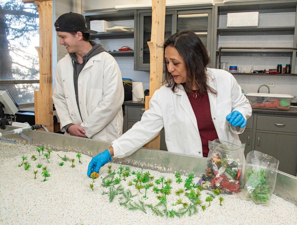
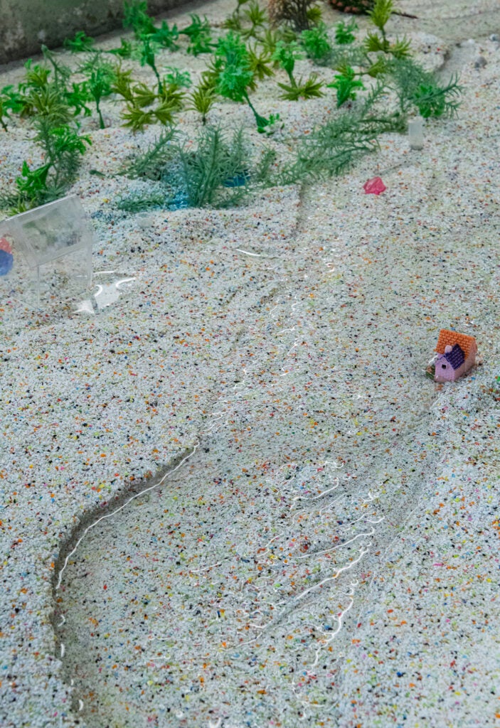
Pradhanang and laboratory manager Brendan McCarron recently demonstrated use of URI’s emulated river simulation table, a 10×3.5-foot-long table which is fed water via piping, simulating rainfall and natural conditions. The water makes its way through simulated communities, with artificial sand standing in for soil. Each river table simulation is modified by the user and desired scenario. Users can add elements to help create their desired landscape: farm, suburban, or urban. These scenarios mimic real-world watersheds and landscapes, dealing with water flowing from upland areas. Users can then manually control the flow rates for either normal low-flow or storm surges, as well as precipitation events. This lets observers see the impacts and changes a watershed experience in a small-scale replica. Houses and farms can be swept away, or might be left high and dry depending on the circumstances. Additionally, injecting a blue or green dye into the sand shows the fate and transport of pollutants commonly seen in those scenarios: farms have a high fertilizer runoff, urban areas often have chemical spills. A combination of all of these factors gives a hands-on approach to concepts that are difficult to observe in real-time, giving the user the flexibility to create and manipulate at will. Finally, the water used is then recycled for the next user scenario.
Rainfall-driven floods in California made the news at the start of this year and the anniversary of Rhode Island’s historic floods of March 2010 is fast approaching — what’s ahead in Rhode Island and other parts of the country, as far as flooding and similar water events?
Management of drought and wastewater is important, as we see these big whiplash effects of weather. Rain can have a cascading and domino effect. With flooding, the domino topples and the water cannot find anywhere to go, especially in cities with impervious surfaces. More green areas can help minimize the effects of climate change and the destructive impact of flooding water.
In the past, cities and states would just think about managing drought; now we need to think about how to manage droughts and floods together.
Stormwater management is also a concern, especially in urban areas.
You teach a course in Global Climate Change every spring, as one of the University’s Grand Challenge courses. How do you discuss water’s impact with your students?
Our students at URI are dedicated and passionate about this topic.
With our graduate students, we conduct watershed modeling to allow students to predict events like this and apply climate change scenarios to help make informed decisions and planning efforts.
At the undergraduate level, I also teach University’s Grand Challenge courses such as Introduction to Water Resources and Global Climate Change, as students learn to tackle big problems, one piece at a time.
Students in all parts of our state and country live near rivers that have an impact on their community’s wellness, safety, and health, so it’s a relatable topic.
Water issues make the news. How important is it for students to learn how to communicate about science and events like this?
I emphasize the importance of communication in my classes. If you can’t communicate with planners and managers, the decision makers, to make the information accessible and understandable, your science will not be complete.
What do you want to tell people about the field of water management?
We want to bring more awareness to the issue. I’d love to collaborate with high schools, letting students see and use our river demonstration table to see how floods interact with the landscape.
The table provides a wonderful simulation for students and the public to visualize water in their community. When you manage water, the negative impacts can be minimized.
Water management is a collaborative undertaking. State entities can work together to get ahead of these issues.
What efforts are in place to prevent these catastrophic floods?
When we look at what happened in California earlier this winter, there are great scientists out there, but it’s a big state with a lot of variability. Last year’s drought in Rhode Island, though shorter term, had a direct effect on Rhode Island’s agricultural products. Scientists anticipate more extreme weather in the future and all of these scenarios together have cascading effects.
All parts of the water cycle are going through some change. Based on climate change projections, we expect that New England will have more extreme weather in its future.
Awareness and outreach will help.
Rhode Island’s local economy has been affected by water issues in the past. Due to the summer’s drought, fall apples were smaller and Christmas tree farms were closed in some areas. Many here remember the flooding of the Pawtuxet River in 2010, closing schools and disrupting businesses across the state. What should we be concerned about now in this part of the country?
Some floods are predictable, some are not. There are always uncertainties. The floods in Providence this past Sept. 6 came as a surprise; the resulting flooding, stopping traffic on Providence’s Thurbers Avenue curve, was an infrastructure issue. Events like this happen when there are not enough green spaces in the environment.
Even where I live in South County, there can be local hazards. It’s important for people to report concerns they see in their own neighborhood. Watch what happens when it rains, be a weather and water watcher, and if you see rainwater flooding, let the DOT or your town know. Having local eyes on local infrastructure helps; report what you see. This can prevent larger problems when big storms come.
The goal of our water simulation table here at URI is to make all of this more understandable for students and the public. We hope to share this with town administrators to help planners better visualize water in the environment. Anyone is welcome to visit and watch the table at work, to assess water issues in their own community.
Kids, in particular, enjoy the table — and have a real ‘aha’ moment to see it working — but anyone can use and learn from it.
Water has an impact on all of us personally; it’s essential for life, important for recreation, or can be dangerous and need to be managed.
The goal of the water table is to help decision makers make better decisions. We want to help generate more problem-solving and creative thinking about water issues.
To speak to Dr. Pradhanang or schedule a visit to the URI’s water simulation table, please contact spradhanang@uri.edu ).