
 Written by Rudi Hempe
KINGSTON, R.I. – Aug. 19, 2011 – Rising sea levels are posing considerable concern among those who have property along the coastline. One such property steward is the National Park Service, and it is looking to University of Rhode Island experts to help it document the location and elevation of specific areas of interest called “sentinel sites” contained within several parks along the Northeast coastline.
The sentinel sites can be ecological features such as wildlife habitats, cultural features such as shipwrecks, or even infrastructure such as bridges, trails or roadways, explained Peter August, professor in the Department of Natural Resources Science.
August and his team of Michael Bradley, Charles LaBash and Angelica Murdukhayeva from the URI Environmental Data Center are all working on a three-year grant from the park service to provide extremely accurate elevations of the sentinel sites and estimates of their risk of inundation from sea level rise and storm surge. This information is needed so that National Park Service managers can properly plan land use and management activities to protect these important sites in the various parks.
“The idea was to determine the likelihood that these special locations would be above or below water because of sea level rise and major storm surges,” said August.
Globally sea level rise has accelerated since the 19th century due to the expansion of warmer waters and melting glaciers.
The URI team will document sentinel sites in 10 national parks extending from Acadia National Park in Maine to the George Washington National Monument and the Colonial National Historic Park in Virginia. In between they will work in the Boston Harbor Islands National Recreational Area, the Cape Cod National Seashore, Ellis Island and the Statue of Liberty National Monument, the Fire Island National Seashore, the Gateway National Recreational Area, and the Assateague Island National Seashore.
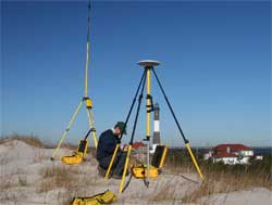
The team’s first task is to verify survey benchmark locations in each park. Benchmarks will provide the reference points for setting up sophisticated GPS (global positioning systems) gear that will communicate with portable GPS gear located at a sentinel site. August said searching out data on the old benchmarks was very labor intensive because the data were widely scattered. “Some were terrific monuments when they were put in place in the 1930s, and for some, no one has seen them since,” he said.
Back at URI, much of the work will be done by Murdukhayeva whose responsibility will be to determine the most accurate models for the calculation of sea level rise and storm surges at sentinel sites. The latter is particularly difficult because of the variables that are involved such as wind direction and speed and the timing in relation to normal tides. And of course the predictions on long-term sea level rise are fraught with debate over variables as well, such as the rate of shelf ice melting in the Arctic, the rate of subsiding land elevations and the melting of the Greenland ice cap.
Once a good benchmark is determined, a GPS base station is set up there and a portable GPS unit is placed at the sentinel site. Data are then transmitted via a radio link between the units on the ground and processed real-time with data from satellites.
Once the GPS data are collected on all the sites, the next step for the National Park Service will be to decide what they need and can do to protect the sentinel sites from inundation. Those decisions may be difficult—for example for an archeological site, should they leave it in place or dig it up and move it to higher ground? If the sentinel site involves infrastructure, decisions will have to be made ranging from relocating a roadway or a visitor center, for example.
The technology and modeling that URI brings to this project will result in highly accurate estimates of the inundation risk of potential inundation of each site, said August. “We’re talking inches not feet. We have the technical expertise – Mike and Chuck know all the technology and Angelica knows the models,” said August.